

Shadow Diagrams
If you have been asked to provide shadow diagrams for a development application, you may notice the same date appearing repeatedly: 21 June. The reason lies in Australia's winter sun conditions — but 21 June is a common assessment date, not a universal requirement for every project.
In Brief
21 June falls around the winter solstice in Australia, when the sun follows a lower path across the sky and built form generally casts longer shadows. This makes midwinter a useful reference condition for documenting potential overshadowing. Many planning authorities use 21 June in shadow assessment requirements, although the required dates, times and diagram formats depend on the applicable planning controls and project.
What is significant about 21 June?
In Australia, 21 June falls around the winter solstice. At this time of year, the sun reaches a lower position in the sky than it does during the warmer months.
For a building, that lower solar position generally produces longer cast shadows. A wall, roof, upper storey or other part of a development can therefore project shadow further across the surrounding site than it would under a higher summer sun.
This makes midwinter useful for planning documentation where the extent of shadow from proposed built form needs to be clearly understood.
The date provides a consistent winter reference condition rather than leaving the shadow assessment to an arbitrary day of the year.
Why is midwinter useful for shadow assessment?
If your proposed development is close to neighbouring buildings or outdoor areas, winter conditions can reveal shadow relationships that may be less apparent at other times of year.
Shadow diagrams can show where existing shadows already fall and how that condition changes when the proposed development is introduced. This can make the additional shadow associated with changes in building height, massing, setbacks, roof form or other built elements easier to identify.
Using a defined winter date also gives the project team and assessment authority a common reference point. Rather than describing overshadowing in general terms, the drawings document what occurs under a nominated set of solar conditions.
This is why 21 June appears so frequently in Australian planning documentation.
21 June provides a useful winter reference condition. It does not create one universal shadow-diagram requirement for every project in Australia.
Do all Australian projects require shadow diagrams for 21 June?
No. Seeing 21 June used frequently does not mean every development application in Australia must use the same assessment date.
The appropriate requirements depend on the project location, development type, planning pathway and applicable planning controls. An authority may nominate midwinter, particular assessment times, additional dates or specific drawing formats depending on what needs to be documented.
Even where two projects both use 21 June, their documentation requirements may not be identical. One project may require several plan-based diagrams, while another may require more frequent time intervals, elevation views or additional information about affected surrounding properties.
The applicable planning requirements should therefore be confirmed before the shadow study is prepared rather than assuming a standard set of dates and times will apply.
Why are several times shown on the same day?
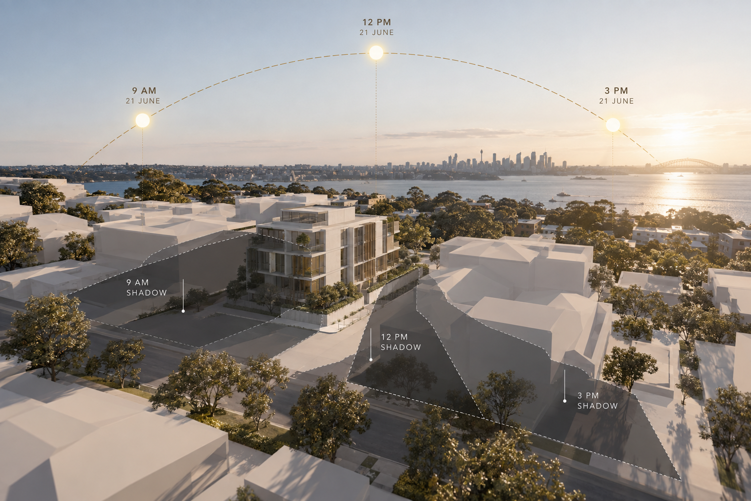
A single diagram only captures the shadow condition at one moment. As the sun changes position through the day, the direction and extent of the shadow cast by the same building also changes.
For this reason, planning requirements may nominate several assessment times on 21 June. Looking at the sequence allows the movement of shadow across the site and surrounding properties to be documented rather than relying on one isolated snapshot.
Times such as 9am, 12pm and 3pm are commonly encountered in planning documentation, while some authorities or projects may require more frequent intervals.
The nominated times should therefore come from the requirements applying to the project rather than being treated as a universal Australian convention.
What does a 21 June shadow diagram actually show?
A 21 June shadow diagram documents where cast shadow falls at the nominated assessment time. Depending on the project, it may show shadow across the subject site, adjoining land, neighbouring buildings, outdoor areas or other relevant surrounding context.
Where existing and proposed conditions are shown separately, the drawings can also help distinguish shadow that already occurs from the additional shadow associated with the proposed works.
For a broader explanation of what these drawings show and how they are used within planning documentation, see the Shadow Diagrams guide.
What the diagram does not determine by itself is whether the resulting solar access satisfies a particular planning criterion. Where the shadow evidence needs to be interpreted against sunlight duration, neighbouring amenity or specific planning requirements, a broader Solar Access & Overshadowing Analysis may be required.
Can shadow diagrams use dates other than 21 June?
Yes. A project may require shadow documentation for another date or for more than one seasonal condition.
Different assessment dates can document different shadow conditions because the position of the sun — and therefore the shadow cast by the same building — changes throughout the year. Some planning pathways may nominate additional seasonal studies where those conditions are relevant to the assessment.
This does not make one date more correct than another in isolation. The purpose of the drawings is to respond to the assessment conditions relevant to the particular project.
If another date is specified by the applicable planning controls, authority request or agreed project scope, that requirement should guide the modelling rather than substituting 21 June simply because it is commonly used elsewhere.
What information is needed before a 21 June shadow diagram is prepared?
Knowing the assessment date is only one part of preparing a reliable shadow study.
The modelling also needs to represent the proposed building and relevant site conditions accurately. Architectural drawings, survey information, site levels, orientation and surrounding built context may all influence where the calculated shadow falls.
Any planning requirement that specifies dates, times or presentation expectations should ideally be identified before modelling begins.
This helps ensure the finished diagrams answer the actual planning question rather than applying a generic shadow-study convention to the project.
Does a 21 June shadow diagram prove solar access compliance?
Not on its own. A shadow diagram provides graphical evidence of where shadow falls under the nominated conditions.
A planning control may ask a different question: for example, how much direct sunlight remains available to a particular window or outdoor area, or whether a defined solar access requirement is achieved. Answering that question requires the shadow evidence to be considered against the relevant planning criteria.
This distinction matters because a drawing can accurately show the location of a shadow without, by itself, establishing whether the resulting solar access outcome is acceptable.
Shadow diagrams document the physical shadow condition. Solar access assessment considers what that condition means within the applicable planning framework.
What if your planning requirements specify something different?
If your council, consent authority or project documentation specifies a particular assessment date, time interval or presentation method, that project-specific requirement should guide the shadow study.
A familiar convention should not override the planning framework that applies to the site. This is particularly important where additional dates, hourly intervals, elevation diagrams or information about neighbouring properties have been requested.
Checking those requirements early can also avoid preparing a technically accurate set of diagrams that does not contain the information required for the application.
The objective is therefore not simply to produce a 21 June diagram. It is to prepare shadow documentation that responds to the assessment requirements of the project.
21 June within the wider shadow assessment
If 21 June appears in your planning requirements, it provides a defined winter condition under which the shadow created by the development can be documented and compared.
Its value comes from the combination of lower winter sun angles and a consistent assessment date — not from a single rule that applies to every Australian project.
The date, times and level of documentation should therefore follow the requirements relevant to your development.
Within that framework, well-prepared shadow diagrams provide a clear record of where existing and proposed shadows fall and how the proposed built form changes the shadow condition.
Continue Reading
Understand the wider role of Shadow Diagrams
Assessment dates are one part of a shadow study. Explore what shadow diagrams show, how they are prepared and how they support planning and development documentation.
Explore the Shadow Diagrams guide →Shadow Diagrams
Need Shadow Diagrams for your project?
The appropriate dates, times and level of shadow documentation depend on your project, site and applicable planning requirements.
Send us your plans and available project information. We can review the project and help identify the appropriate assessment pathway.
Start Your Project