

When a project requires visibility modelling, two terms may appear in the assessment brief: viewshed analysis and line-of-sight analysis. Both examine whether an unobstructed visual relationship may exist, but they do not necessarily produce the same type of information.
A line-of-sight analysis generally investigates visibility between nominated locations. A viewshed analysis extends visibility calculations across a defined area to identify a broader spatial pattern of potential visibility.
For architects, planners, developers and infrastructure project teams, understanding this distinction helps clarify which method can answer a particular design or planning question, and what information should be expected from the resulting analysis.
Line-of-sight analysis examines a nominated visual connection. Viewshed analysis maps potential visibility across an area. The methods are related, but their outputs answer different spatial questions.
In Brief
What Is the Difference Between Viewshed and Line-of-Sight Analysis?
Line-of-sight analysis tests whether a nominated observer and target have a potential unobstructed sightline under specified modelling conditions.
Viewshed analysis evaluates visibility across multiple locations within a defined geographic area, commonly producing a map showing modelled visible and non-visible zones.
Both approaches depend on elevation information, observation and target heights, and assumptions about relevant obstructions.
The appropriate method depends on whether the project needs to answer a specific point-to-point visibility question or understand the wider geographic distribution of potential visibility.
Assessment boundary: Neither method independently determines the significance of a visual effect, the sensitivity of a viewer or whether a proposed development is acceptable in planning terms. Those matters may require separate visual impact assessment and project-specific evidence.
1. What Does Line-of-Sight Analysis Test?
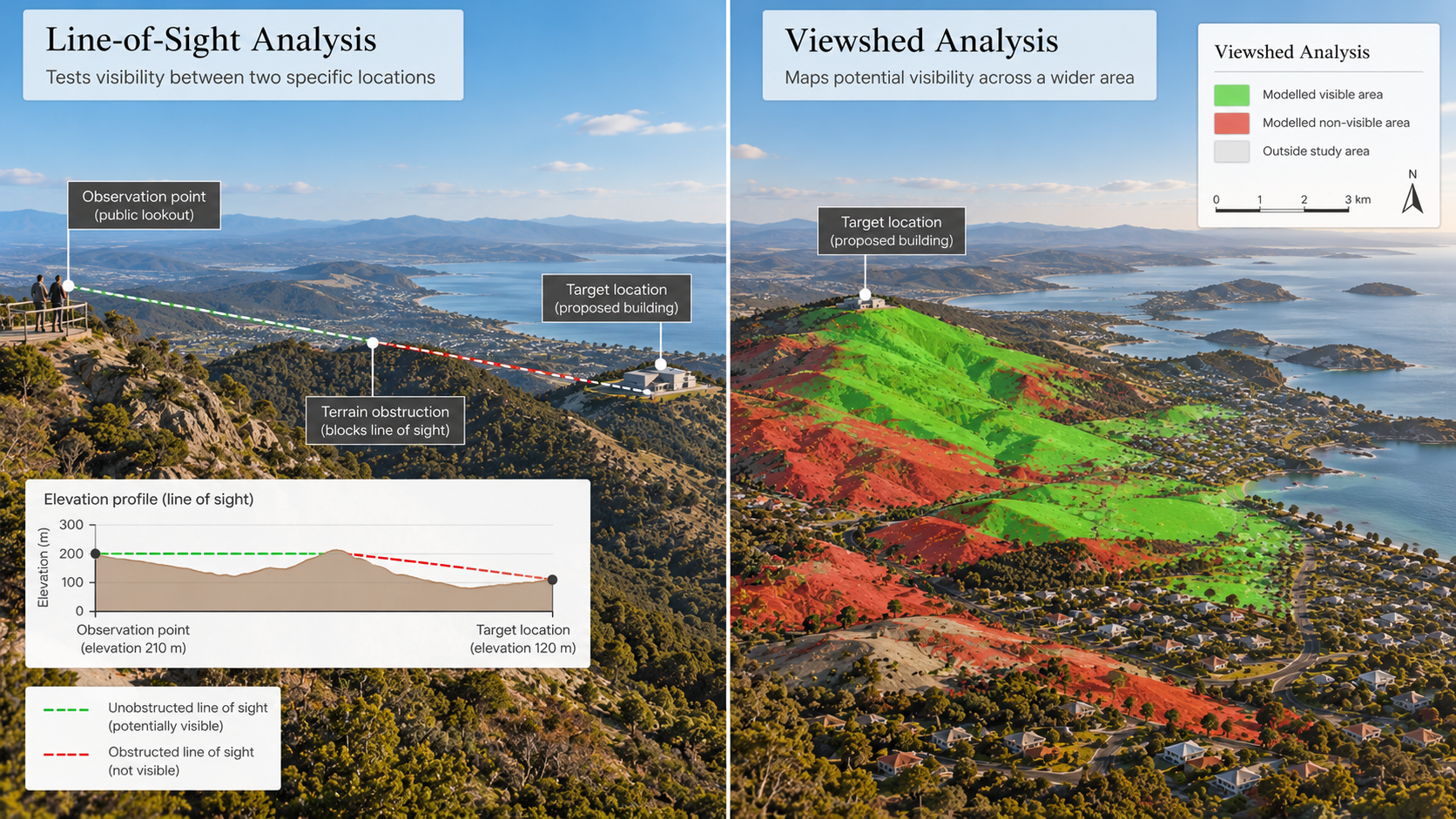
Line-of-sight analysis examines the geometric relationship between an observation location and a nominated target. The calculation considers whether the straight sightline between those locations intersects terrain or other obstructions represented in the model.
For example, a project team may need to establish whether a proposed structure could be visible from a particular public lookout, road location or neighbouring property.
The analysis may produce a visible or obstructed classification, a sightline diagram, an elevation profile or other information relevant to the selected calculation method.
A line-of-sight result is specific to the locations, heights and model inputs used. It should not be assumed to represent every possible observer position nearby.
Where several viewpoints are relevant, multiple sightlines may be tested individually or as part of a wider visibility modelling exercise.
2. What Does Viewshed Analysis Test?
Viewshed analysis examines potential visibility across a defined geographic area rather than limiting the result to one nominated sightline.
A model may calculate which locations are potentially visible from an observation point, or which locations may have visibility towards a nominated target. The direction and arrangement of the calculation should be specified in the methodology.
The resulting output is commonly presented as a map identifying areas classified as visible or non-visible under the model assumptions.
Some workflows combine multiple observation points or target locations to investigate a wider set of visibility relationships.
For the broader explanation of the method and its applications, refer to the Viewshed Analysis Knowledge Pillar.
3. Point-to-Point Visibility vs Area-Wide Visibility
The most useful distinction is the spatial question being answered.
A point-to-point calculation asks whether a nominated visual connection exists between specific locations. This can be appropriate when the relevant observer and target positions are already known.
An area-wide analysis asks where potential visibility occurs across a larger study area. This can help identify locations that may warrant further investigation before individual viewpoints are selected.
For example, testing a sightline from one lookout to a proposed building is a narrower task than mapping the surrounding areas from which the building may be visible.
Neither spatial approach is inherently more appropriate. The choice depends on the purpose, scale and evidence requirements of the project.
4. The Modelling Principles Both Methods Share
Both methods rely on geometric visibility relationships and the elevation information used to represent the study area.
A calculation may consider ground elevation, observer height, target height and obstructions represented along the tested sightline.
Depending on the assessment, additional assumptions may relate to the curvature of the Earth, atmospheric refraction, maximum analysis distance or the treatment of buildings and vegetation.
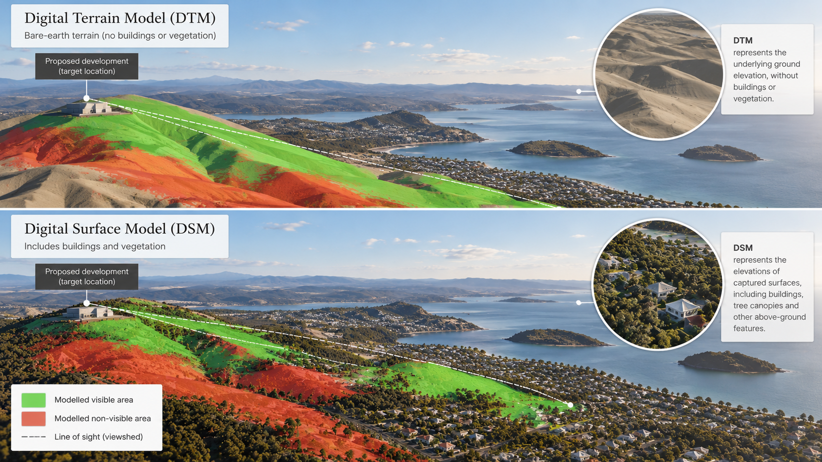
The distinction between a Digital Terrain Model and Digital Surface Model is relevant to both methods because it affects which elevated features are represented.
A larger number of calculated sightlines does not eliminate uncertainty in the underlying data. The same limitations can influence both a single sightline and a broader visibility map.
5. When a Line-of-Sight Analysis May Be Appropriate
Line-of-sight analysis can be useful where a project needs to investigate a defined visual relationship between specific locations.
This may include checking potential visibility between a nominated public viewpoint and a proposed structure, reviewing a selected sightline across a development site, or examining whether terrain obstructs a particular viewing direction.
Where the question concerns a limited number of well-defined locations, individual sightline calculations may provide an appropriately focused technical output.
However, a single tested line should not be used to conclude that a feature is invisible throughout the surrounding area.
If the assessment needs to identify additional potentially affected locations, a wider viewshed analysis may be more informative.
6. When Viewshed Analysis May Be More Appropriate
Viewshed analysis may be useful when the assessment requires an understanding of potential visibility across a wider geographic area.
For example, a proposed development may be located within a landscape containing several roads, residential areas and public observation locations. A viewshed map can help identify the spatial distribution of potential visibility before more detailed review.
The method can also support early-stage design comparisons where a project team wants to understand how changes to a nominated structure or location influence modelled visibility.
The output may inform further viewpoint selection or site verification, but it does not independently establish the significance of visual effects.
For additional project context, see When Do You Need a Viewshed Analysis?.
7. Why Observer and Target Heights Matter
A visibility calculation depends on the heights assigned to the observation and target locations.
An observer positioned at ground level may have a different calculated sightline from an observer at an elevated platform or upper-storey window.
Similarly, testing visibility towards the base of a proposed building may produce a different result from testing its roofline or another nominated height.
These assumptions apply to both individual line-of-sight calculations and area-wide viewshed modelling.
For a reliable comparison, the report should identify the height references and explain which part of the proposed feature is represented by the target.
8. How the Outputs Differ
A line-of-sight analysis may be presented through a sightline diagram, terrain profile or other visual representation showing the relationship between the observer, target and intervening elevations.
A viewshed analysis commonly produces a map showing modelled visible and non-visible areas across the selected study extent.
The map may use binary visibility classes or show a combined result from multiple observation locations, depending on the modelling method.
Both outputs should be accompanied by sufficient information to understand the tested locations, elevation data and modelling assumptions.
For a practical explanation of map legends and visibility classifications, see How to Read and Interpret a Viewshed Map.
9. What Neither Method Can Establish on Its Own
A modelled sightline does not necessarily mean that a feature will be clearly noticeable in real-world conditions.
The apparent scale of a development, atmospheric conditions, colour, contrast and the surrounding visual context may influence how a feature is experienced.
Likewise, a viewshed map showing potentially visible areas does not identify which locations have high visual sensitivity or whether a proposed change is significant.
These matters belong to a different assessment question. Where required, a Visual Impact Assessment can examine the nature and significance of visual effects within the relevant planning context.
Visibility modelling can inform that work, but should not be presented as a substitute for it.
10. Choosing the Appropriate Visibility Analysis Method
The starting point should be the project question rather than a preference for a particular mapping technique.
If the task is to test visibility between two nominated locations, a line-of-sight calculation may be sufficient.
If the task is to identify the geographic distribution of potential visibility, a viewshed analysis may provide a more suitable output.
Some projects may benefit from both approaches. A broader viewshed can identify areas for further investigation, while selected line-of-sight profiles can examine particular relationships in greater detail.
The final assessment scope should reflect the project setting, available data, required level of detail and intended use of the findings.
Viewshed Analysis vs Line-of-Sight Analysis: Comparison
The following table summarises the practical differences between the two approaches. Specific workflows may combine elements of both.
| Characteristic | Line-of-Sight Analysis | Viewshed Analysis |
|---|---|---|
| Primary question | Is there a potential sightline between nominated locations? | Where does potential visibility occur across an area? |
| Spatial scope | Selected observer-target relationships | Defined geographic study area |
| Typical output | Sightline diagram, profile or visibility result | Map of modelled visibility zones |
| Observation locations | One or more nominated points | One or more points evaluated across a wider area |
| Elevation data | Required for terrain-based modelling | Required for terrain-based modelling |
| Useful application | Testing a specific visual connection | Identifying broader visibility patterns |
| Key limitation | Does not describe visibility outside the tested relationships | Does not independently assess visual significance |
Before Selecting a Visibility Analysis: Project Checklist
☐ Define the visibility question the project needs to answer.
☐ Identify whether the relevant viewpoints are already known.
☐ Establish whether point-to-point or area-wide visibility is required.
☐ Confirm the proposed structure or target to be modelled.
☐ Identify the observation and target height assumptions.
☐ Check the availability of suitable elevation data.
☐ Consider whether buildings and vegetation are relevant obstructions.
☐ Confirm the geographic extent and required level of detail.
☐ Determine whether selected sightline profiles would supplement a viewshed map.
☐ Distinguish visibility modelling from visual impact assessment.
☐ Confirm the expected outputs and methodology before assessment begins.
What Happens When the Visibility Question Changes?
A project may begin with a narrowly defined visibility question and later require a broader investigation.
For example, an initial line-of-sight calculation may test a proposed building against one nominated viewpoint. During design development, the project team may need to understand visibility from additional roads, public spaces or surrounding land.
The assessment scope may then expand to include multiple sightlines or area-wide viewshed modelling.
Changes to the building height, site layout, observer locations or elevation information may also require the calculations to be reviewed.
Clear documentation of the original question and modelling assumptions helps establish which additional work is needed without treating an earlier limited result as a comprehensive assessment.
Illustrative Example: Testing Visibility of a Proposed Building
Consider a proposed building on an elevated site near an established residential area.
The project team initially wants to know whether the building roofline could be visible from a nominated public lookout.
A line-of-sight calculation tests the relationship between the lookout and a specified point on the proposed building, using nominated heights and available elevation data.
Later, the team needs to identify which surrounding roads and residential locations may have potential visibility towards the proposal.
A viewshed analysis is undertaken across the defined study area, using an appropriate target arrangement and documented assumptions.
The resulting map identifies locations for possible further review, while selected line-of-sight profiles provide additional detail for particular viewpoints.
This illustrative example demonstrates how the two methods can complement one another without performing the same assessment task.
Frequently Asked Questions
Viewshed and Line-of-Sight Analysis FAQs
Is viewshed analysis the same as line-of-sight analysis?
No. Both use visibility calculations, but line-of-sight analysis generally examines nominated visual connections, while viewshed analysis maps potential visibility across a defined area.
Can a viewshed analysis include line-of-sight calculations?
Yes. Viewshed modelling commonly evaluates line-of-sight relationships between observation locations and locations across the study area. Individual sightline profiles may also be prepared to investigate selected relationships in greater detail.
Which method is better for a proposed building?
It depends on the question. A line-of-sight calculation may be suitable for a specific viewpoint, while viewshed analysis may be more appropriate for identifying potentially visible locations across a wider surrounding area.
Does line-of-sight analysis account for buildings and trees?
It can, where suitable obstruction data is included in the model. A calculation based only on bare-earth terrain generally will not represent buildings and vegetation as screening.
Does a viewshed map prove that a development will be visible?
A viewshed map identifies modelled potential visibility under specified assumptions. It does not necessarily establish real-world visibility at every location or determine the prominence and visual significance of a proposal.
Can both methods be used in the same planning assessment?
Yes. A viewshed analysis may identify potentially visible areas, while selected line-of-sight calculations provide additional information about particular observation and target relationships. The appropriate combination depends on the project scope.
Related Knowledge
Related Visibility Modelling and Planning Guidance
Viewshed Analysis
Explore the wider principles and applications of spatial visibility modelling.
How to Read a Viewshed Map
Understand visibility classes, map legends and interpretation of modelling results.
Digital Terrain Models vs Digital Surface Models
See how different elevation datasets influence visibility calculations.
When Do You Need a Viewshed Analysis?
Understand project circumstances in which area-wide visibility modelling may be relevant.
Professional Visibility Modelling
Need to Understand Visibility for Your Project?
Certified Energy can help establish an appropriate visibility modelling scope for a proposed development or infrastructure project. Share your project details to discuss the relevant observation locations, modelling requirements and assessment outputs.
Request a Viewshed Analysis